|
|
Demography | Geography |
Education | Brief History |
Tribes & Clans |
Places of Interests
 Mianwali
is a District in the north-west of Punjab province, Pakistan. It borders
Lakki Marwat district in the west, Kohat and Karak districts in the North
west and Dera Ismail Khan District in the southwest. Attock lies in the
north, Chakwal in the north east, Khushab in the east and Bhakkar in the
south. Mianwali
is a District in the north-west of Punjab province, Pakistan. It borders
Lakki Marwat district in the west, Kohat and Karak districts in the North
west and Dera Ismail Khan District in the southwest. Attock lies in the
north, Chakwal in the north east, Khushab in the east and Bhakkar in the
south.
In November 1901, the North-West Frontier Province was carved out of Punjab
and present day towns of Mianwali, Isa Khel, Kalabagh, and Kundian were
separated from Bannu District (NWFP) and hence a new district was made with
the headquarters in Mianwali city and placed in Punjab province.
Search Mianwali on Satellite
Map
Places of Interest
| Hotels |
Parks & Gardens |
Educational Institutes |
Hospitals |
Banks |
Fuel Stations |
CNG Stations |
Police Stations |
Shopping /Trade
Demography
According to the 1998 census of Pakistan, the district had a population of
1,056,620 out of which 20.39% i.e. 85,000 inhabitants live in the district
capital Mianwali. Niazi tribe is the most dominant and major tribe of this
district with an estimated 70% of the total population. Niazi tribe exists
in all parts of the district but most notably living in Mianwali City,
Shahbaz Khel, Musa Khel, Mochh, Utra Kalaan, Sawans. Another tribe known as
Jats live mostly inDing Khola, New Ding Sharif , Saeed Abad ,Hashim Naggar/Lal
wala(Saifun Pull),Khan Qah Sirrajia, Bakharra/Kacha Kalo, Kacha paar,khita-e-Atlas,
Kacha Gujrat, Kacha Shahnawaz Wala, Phaati, Hurnoli, Alluwali, Duaba, Jaal
Janub/Shumali , Piplan,Wan Bahhchran,
Wichveen Bala,Kundian, Moosa Khel, Shadia an so on. There are small minority
of Pashtuns and Punajbis.
Mostly people in the district speak a unique dialect of Seraiki which
borrows many words from Hindko, Pashto and Sindhi. However the Khattak
tribes living in the suburbs of Isakhel, Chapri, Bhangi Khel, Sultan Khel,
Makarwal and Bani Afghan are bilingual, Pashto being their primary language
but can fairly communicate in Seraiki as well. Awans living in the Salt
range of Mianwali speak a dialect of Potohari which is called "Uttraadi"(pertaining
to the highlanders
Go To Top
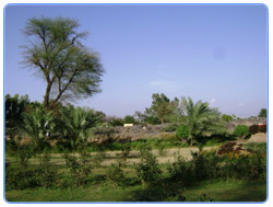
Geography
,Ex-Governor%20West%20Pakistan..jpg) Nawab
of Kalabagh Malik Amir Muhammad Khan(1910–1967),Ex-Governor West
Pakistan.Mianwali district covers an area of 5,840 square kilometres. The
area in north is a continuation of the Pothohar Nawab
of Kalabagh Malik Amir Muhammad Khan(1910–1967),Ex-Governor West
Pakistan.Mianwali district covers an area of 5,840 square kilometres. The
area in north is a continuation of the Pothohar
Plateau and the Kohistan-e-Namak. The district consists of various towns,
including Kalabagh, Is a Khel, Kundian, Paikhel, Piplan, Kamar Mushani,
Mochh, Rokhri, Harnoli, Musa Khel, Wan Bhachhran, Daud Khel and the district
capital - Mianwali city.
Mianwali City is the capital of Mianwali district. It is the largest city of
the district with a population of about 85000 people and economic &
commercial hub of the district.
Kundian is the second largest town at a distance of 15 km from the city of
Mianwali. Important sites such as Chashma Nuclear power plant(Chashnupp),
Chashma Barrage, Kundian-Jehlum or Chashma-Jehlum) Link Canal are located.
Piplan is another important town and tehsil headquarter located in the
souther part of the district.
Kalabagh is famous for the Kalabagh Dam and the Nawab of Kalabagh and for
the red hills of the salt range and scenic view of mighty Indus River.
Isa Khel is another important town and tehsil headquarter located in the
west of Mianwali. It is a historical town named after *Isa Khan, a famous
Niazi chief.
Kamar Mushani is famous for its trade and minerals.
Mochh is another important town of Mianwali district.
Go To Top
Education
Mianwali district has several educational institutions from elementary up to
post-graduate level,affiliated with the University of Punjab. There are
numerous private schools and colleges in the district.
Find more about
Worldwide Education
Go To Top
Brief History
Traditionally all major rulers of South Asia governed this area in their
turn. Mughal emperor Babur mentions Isa khel whilst he was fighting against
the Pakhtuns as part of his campaign to conquer the Punjab during the 1520s
(ref. Baburnama). Then came the Sikhs, that era was famous for lawlessness,
and barbarism, they ruled until the annexation of Punjab in 1849 by the
British. During British rule, the Indian empire was subdivided into
province, divisions and districts, (after the independence of Pakistan
divisions remained the third tier of government until 2000). The British had
made the towns of Mianwali and Isa Khel tehsil headquarters of Bannu
District then part of Dera Ismail Khan Division of Punjab province.
The district of Mianwali was created in November 1901, when the North West
Frontier Province was carved out of Punjab and the towns of Mianwali, Isa
Khel, Kalabagh, and Kundian were separated from Bannu District which became
part of the NWFP. A new district was made with the headquarters in Mianwali
city and placed in Punjab, the district became a part of Multan Division.
Mianwali originally contained four tehsils namely Mianwali, Isa Khel,
Bhakkar, and Layyah, in 1909 Layyah was transferred to Muzaffargarh
District. The district became a part of Sargodha Division in 1961, in 1982
Bhakkar tehsil was removed from Mianwali and became a separate district of
Sargodha Division
The Rule of the Ghakkars in the North - Invasion of Nadir Shah in 1738
Prior to the invasion of Nadir Shah in 1738, there is little to relate
concerning the history of the northern part of the district. The upper half
of the district was ruled by the Ghakkars, who became feudatories of
the Mughal Empire, of which the district continued to form a part until the
invasion of Nadir Shah. In 1738 a portion of his army entered Bannu, and by
its atrocities so cowed the Bannuchis and Marwats that a heavy tribute was
raised from them. Another portion of the army crossed the Pezu pass and
worked its way down to Dera Ismail Khan. The country was generally plundered
and contingents raised from the neighbourhoods of Bannu and Dera Ismail Khan
marched under Nadir Shah's banner to the sack of Delhi. In 1739 the country
west of the Indus was surrendered by the Emperor of Delhi to Nadir Shah, and
passed after his death to Ahmad Shah Abdali.
Expulsion of the Ghakkars in 1748
In 1748 a Durrani army under one of Ahmad Shah's generals crossed the Indus
at Kalabagh, and drove out the Ghakkars, who still ruled in the cis-Indus
tracts of the district, owing nominal allegiance to the Emperor at
Delhi.Their stronghold, Muazzam Nagar, was razed to the ground, and with
their expulsion was swept away the last vestige of authority of the Mughal
Emperor in these parts.
The armies of Ahmad Shah marched repeatedly through the district, the cis-Indus
portion of which was, with the rest of the Punjab, incorporated in the
Durrani Kingdom in 1756, and for the next sixty years a precarious hold was
maintained on their eastern provinces, including this district, by Ahmad
Shah and his successors to the throne of the newly created Kingdom of Kabul.
The history of the Bhakkar Tehsil comprising the southern part of the
district (both in the period which preceded and that which followed the
incorporation of the district in the Durrani Kingdom) requires separate
recording. Its history is bound up with that of Dera Ismail Khan and of
Leiah, and to some extent with that of Dera Ghazi Khan.
During the reign of Ahmad Shah, no regular Governors were appointed by the
Kabul Government. The country was divided between the Hot and Jaskani
chiefs, whose predecessors had been the first Biluch chiefs to form
settlements along the Indus.
Find more about
History of Pakistan
Go To Top
Tribes & Clans
The populations of the district is split into four main groups, the
predominant Niazi tribes who are mainly present in riverain Mianwali Tehsil
and Isa Khel Tehsil, the Awans who are found mainly in the Salt Range and
Kalabagh in Isakhel Tehsil. The Thal desert portion is held by Jat and
Baluch tribes. The city of Mianwali and town of Wan Bhachran are both home
to the Qureshi - Makhdooms and Miana tribes respectively.
The district includes descendents of refugees from East Punjab and Haryana
in India, who settled after partition.
Immigration
The district has been settled by triple immigration from opposite
directions; Niazis from the north-west of Pakistan, Awans from the
north-east, and Jats & Balochis up the valley of the Indus from the south.
The Niazis Immigrations
Mahmud of Ghazni is said to have conquered the upper half of the district
and Bannu, expelling its Hindu inhabitants. Hence there was no one left,
capable of opposing the settlement of immigrant tribes from across the
border. The series of Pashtun immigrations into Bannu took place in the
following order:
-
The Bannuchis, who about
five hundred years ago displaced two small tribes of Mangals and Hannis,
of whom little is known as well as
a settlement of Khattaks, from the then marshy but fertile country on
either bank of the Kurram.
-
The Niazis, who some
hundred and fifty years later spread from Tank over the plain, then
sparsely inhabited by pastoral Jats.
The Marwats, a younger branch of the same tribe, who within one hundred
years of the Niazi settlement of Marwat, followed in their wake, and drove
them farther eastward into the region now known as Isa Khel and Mianwali.
 The
Bannuchis must have settled down for nearly two centuries, before the Niazi
arrival into Marwat took place. The Niazis occupied the hills about Salghar,
which are now held by the Sulaiman Khels, until a feud with the Ghilzais
compelled them to migrate elsewhere. Marching south-east, they found a
temporary resting place in Tank. There the Niazais lived for several
generations, occupying themselves as traders and carriers, as do their
kinsmen the Lohani Pawindahs in the present day. At length towards the close
of the fifteenth century, numbers spread north into the plain now known as
Marwat, and squatted there as graziers, and perhaps too as cultivators, on
the banks of the Kurram and Gambila, some fifteen miles below the Bannuchi
Settlements. There they lived in peace for about fifty years, when the
Marwat Lohanis, a younger branch of the Lodi group, swarmed into the country
after them, defeated them in battle, and drove them across the Kurram at
Tang Darra, in the valley beyond which they found a final home. At that
time, Marwat seems to have been almost uninhabited, except by a sprinkling
of pastoral Jats; but the bank of the Indus apparently supported a
considerable Jat and Awan population. The
Bannuchis must have settled down for nearly two centuries, before the Niazi
arrival into Marwat took place. The Niazis occupied the hills about Salghar,
which are now held by the Sulaiman Khels, until a feud with the Ghilzais
compelled them to migrate elsewhere. Marching south-east, they found a
temporary resting place in Tank. There the Niazais lived for several
generations, occupying themselves as traders and carriers, as do their
kinsmen the Lohani Pawindahs in the present day. At length towards the close
of the fifteenth century, numbers spread north into the plain now known as
Marwat, and squatted there as graziers, and perhaps too as cultivators, on
the banks of the Kurram and Gambila, some fifteen miles below the Bannuchi
Settlements. There they lived in peace for about fifty years, when the
Marwat Lohanis, a younger branch of the Lodi group, swarmed into the country
after them, defeated them in battle, and drove them across the Kurram at
Tang Darra, in the valley beyond which they found a final home. At that
time, Marwat seems to have been almost uninhabited, except by a sprinkling
of pastoral Jats; but the bank of the Indus apparently supported a
considerable Jat and Awan population.
The most important sections of the expelled Niazais were the Isakhel,
Mushanis and a portion of the Sarhangs. The first named took root in the
south of their new country and shortly developed into agriculturists ; the
second settled farther to the north roundabout Kamar Mushani, and seem for a
time to have led a pastoral life ; of the Sarhangs, some took up their abode
at Sultan Khel, while others, after drifting about for several generations,
permanently established themselves cis-Indus on the destruction of the
Ghakkar stronghold of Muazzam Nagar by one of Ahmad Shah's lieutenants. That
event occurred about 1748, and with it terminated the long connection of the
Ghakkars with Mianwali.They seem to have been dominant in the northern parts
of the country even before the emperor Akbar presented it in jagir to two
of, their chiefs. During the civil commotions of Jehangir's reign the
Niazais are said to have driven the Ghakkars across the Salt Range, and
though, in the
following reign, the latter recovered their position, still their hold came
to an end about the middle of the 18th century as stated above. The remains
of Muazzam Nagar, their local capital, were visible on the left high bank of
the Indus about six miles south of Mianwali, until the site was eroded by
the river about the year 1870. The Niazais thus established themselves in
Isa Khel over three hundred years ago, but their Sarhang branch did not
finally obtain its present possessions in Mianwali, until nearly 150 years
later. The acquisition of their cis-Indus possessions was necessarily
gradual, the area having a settled, though weak Government, and being
inhabited by Awans and Jats.
Awans
The Awans now occupy part of the district which lies east of the Dhak Spur
of the Salt Range and is known as Khudri, Pakhar, or Awankari. "Men of
Mianwali mostly know the name Pakhar; but residents of the Kacha and Isakhel
generally speak of the tract and parts beyond as utrad. i.e., the high
country."Bannu district Gazetter
They have been almost the sole occupants of that extensive tract for at
least six hundred years and may perhaps have resided there since the Arab
invasions of the seventh century. Previous to the decilne and extinction of
Ghakkar tribe authorities in Mianwali, the Awan possessions extended
westward of the Salt Range. Later, Niazis challenged them and drived them
eastwards.The Awans were amongst those who formed an important part of the
British Indian army, serving with distinction during World Wars I and II.
Along with Rajputs, Awans occupy the highest ranks of the Pakistani army.
Awans claim themselves to be of Arab origin , a claim which is disputed by
many British anthropologists and historians. Some label them as remnants of
"Bactrian Greeks" while the others insist that they are the descendants of
Raja Risalu of Sialkot , thus insisting on their Rajput origins. Some also
relate them to the Qutab Shah who had Arab ancestry thus giving a proof to
their claim.
The Jat and Baloch Immigration
Before the fifteenth century the lower parts of the district wwere probably
occupied by a few scattered tribes of Jats, depending on their cattle for
subsistence. The valley of the Indus was a dense jungle, swarming with pig
and hog-deer, and frequented by numerous tigers; while the Thal must have
been almost unoccupied.
All the traditions of the people indicate that an immigration of mixed
tribes of Jats Talokar/Tilokar/Talukar/Thalokar,(Siyars, Chhina, Khokhars,
&.c.,) set in about the beginning of the 15th century from the Multan and
Bahawalpur direction. They gradually passed up the valley of the Indus to
the Mianwali Tehsil, occupying the intervening country. Most of their
villages would have been located on the edge of the Thal and a portion of
the immigrants probably crossed the river and settled along its right bank.
After these came the Balochis. They also came from the south, but in large
bands under recognized leaders, and they appear to have taken military
rather than proprietary possession of the country. They were the ruling
class, and served under their chiefs in the; perpetual little wars that were
then going on in every direction. It is probable that the Jat immigration
continued for sometime after the Balochis first came into the country.
However it may have been, all the Kachha, immediately adjoining the Thal
bank, seems to have been parcelled off to Jat families. Each block was
accompanied with a long strip of Thal to the back. These estates are the
origin of the present mauzas as far north as Kundian in the Mianwali Tahsil.
They are almost all held by Jats. Here and there, shares are held by
Balochis, but these have mostly been acquired in later times by purchase. In
the same way the unoccupied lands towards the river were divided off into
blocks, and formed into separate estates; and sometimes; where the hads
first, formed had too much waste land, new hads were formed in later times
by separating off outlying portions of the old estates. This division into
hads extended right up to Kundian. In course of time, as the Balochis
settled down in the country, individuals acquired plots of land for wells,
but generally in subordination to the had proprietors or lords of manors.
Here and there a small clan settled down together, but this was the
exception. Balochis are still numerous all through the southern part of the
Kachha, up to Darya Khan; but though they were originally the ruling
race, still, as regards proprietary rights in the land they hold a position
inferior to that of the Jats and Sayyads, by whom the superior
proprietorship of hads is generally held. North of Darya Khan there are very
few Balochis. In the Thal the population is nearly entirely Jat.
Baluch Clans
The Mamdanis of Khansar, the Magsis, a tribe which came in very early, and
settled in the eastern Thal about Dhingana and Haidarabad, and the Durranis
of Dab in the Mianwali Tehsil, are almost the only considerable bodies of
Balochis to be found in the Thal.
The Jat Clans
All through the Kachha the mass of the villages are named after Jat
families, who form the bulk of the proprietors. These are generally the
descendants of the original founders, and have stuck together as like 'Jat
Talokar/Tilokar/Talukar/Thalokar in Ding Khola(Khanqah Sirrajia) and
bakhharra (kachha).'''' In the Thal there are a large number of villages
held in the same way by men of particular families ; but in
most the population is very mixed, nearly every well being held by a man of
a different caste. The only Jat tribes in the Thal deserving of special
mention are the Chhinas and Bhidwals. The Chhina country extends across from
Chhina, Behal, Lappi and Notak, on the edge of the Kachha, to Mankera and
Haidarabad on the further side of the Thal. The Bhidwals possess a somewhat
smaller tract round Karluwala and Mahni in the neighbourhood of the Jhang
border. They have always been a good fighting tribe.
Balouch Pashtuns
A few families of Balouch Pashtuns came across the Indus River from the
Paniala Hills. Of these, one became dominant at Piplan, while the others
moved on into the Thal and took up their abode eventually in and about
Jandanwala.
Wirali
Is a tribe living in Pai Khel,Mianwali.Hundred years ago there was a great
sufi saint, named "Mian Muhammad Wirali".He was a philanthropist
with much regard among the masses.He distributed his land to the poor.Now a
days his shrine is at Pai Khel,in the base of a mountain from
where dolomite is extracted for steel mills. After him, his tribe is known
as "Wirali".
Go To Top
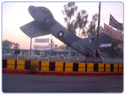
Places of Interests
-
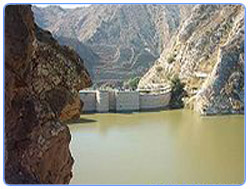 Kalabagh
Dam Kalabagh
Dam
-
Chahshma Barrage and Lake
-
Jinnah Barrage
-
Namal Lake: Namal or (Nammal)
lake is a place of interest for the hikers and holiday-makers near
Chakrala.
-
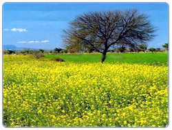
Thal Desert: It is a large
area which is mostly desert and semi-arid. It is located between Jhelum
and Indus river (The Sindh-Saagar Doab). The boundaries of the old
district established in 1901 included almost 70 % of this great area, but
after the separation of Layyah and then Bhakkar Tehsils, only about 20%
remains in this district. First deputy commissioner Mr. A J O'Brian wrote
in his memoirs- "In 1901 the District of Mianwali was formed out of the
two Punjab halves of two older districts, and I had the good fortune to be
put in charge. It was a lonely District with, as my Assistant Mr. Bolster
called it, 'three white men in a wilderness of sand.'
-
River Indus
-
Kalabagh Old town
-
Ruins at Mari Indus & Mari
City: At Mari in the Mianwali Tehsil, there is a picturesque Hindu ruin,
crowning the gypsum hill, locally called Maniot (from Manikot, meaning
fort of jewels), on which the Kalabagh diamonds are found. The ruins
themselves must once have been extensive. It appears that the very top of
the hill was built over with a large palace or fort.
-
Architectural Objects and
Remains: In the southern part of the district the general absence of
antiquarian remains also tends to prove that it can never have been the
site of a rich and populous Government. In the Kachhi tract, of course,
such remains could not survive the action of river floods, and this tract
must, at one time, have been much wider than it is now. The Thal, however,
is admirably suited for the preservation of antiquarian relics, had any
such ever existed, but there are none that date from earlier than the
fourteenth century.
-
.jpg) Architectural
Objects and Remain-Ruins of Sirkapp Fort: Overlooking the village site of
Namal in the Khudri is a ridge of great
natural strength, cut off on three sides by hill torrents. On the top of
this ridge there are extensive ruins of what is said to have been the
stronghold of Sirkapp, Raja of the country , who was a contemporary of
Raja Risalu of Sialkot, by whom he was vanquished. The outerall of the
fort still exists in part in a dilapidated condition, but the enclosure,
which must once have contained accommodation for a fairly large garrison ,
is now one mass of fallen houses and piles of hewn or chiselled stones .
The series of lifts, made for carrying water from the bed of the
stream to the top of the hill, have left their marks. Architectural
Objects and Remain-Ruins of Sirkapp Fort: Overlooking the village site of
Namal in the Khudri is a ridge of great
natural strength, cut off on three sides by hill torrents. On the top of
this ridge there are extensive ruins of what is said to have been the
stronghold of Sirkapp, Raja of the country , who was a contemporary of
Raja Risalu of Sialkot, by whom he was vanquished. The outerall of the
fort still exists in part in a dilapidated condition, but the enclosure,
which must once have contained accommodation for a fairly large garrison ,
is now one mass of fallen houses and piles of hewn or chiselled stones .
The series of lifts, made for carrying water from the bed of the
stream to the top of the hill, have left their marks.
-
Other Antiquities: The
above, together with two sentry-box like buildings, supposed to be
dolmens, midway between, Namal and Sakesar, and several massive looking
tombs, constructed of large blocks of dressed stones in the Salt Range,
comprise all the antiquities above ground in the district. No doubt many
remain concealed beneath the surface. The encroachments of the Indus and
even of the Kurram near Isakhel often expose portions of ancient masonry
arches and wells. The only other antiquity worth mentioning is a monster
baoli at Wanbhachran , said to have been built by order of Sher Shah Suri.
It is in good preservation and similar to those in the Shahpur District.
Go To Top |