|
|
Topography | Demography
| Geography | History |
Historical Sites |
Education | Newspapers and-
Magazines | Libraries |
Tourism | Agriculture |
Food and Health
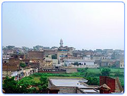 Chakwal
is a district in the Punjab province of Pakistan. Chakwal district was
created in 1985, until the year 2000 when divisions were abolished,it was
part of Rawalpindi Division. Chakwal
is a district in the Punjab province of Pakistan. Chakwal district was
created in 1985, until the year 2000 when divisions were abolished,it was
part of Rawalpindi Division.
Search Chakwal on Satellite
Map
Hotels |
Eating &
Dining | Parks &
Gardens |
Educational Institutes |
Hospitals |
Sport Centers |
Banks |
Fuel Stations |
CNG Stations |
Police Stations |
Shopping /Trade
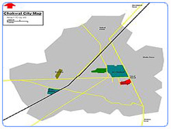
Topography
Chakwal district borders the districts of Rawalpindi and Attock in the
north, Jhelum in the east, Khushab in the south and Mianwali in the west.
The total area of Chakwal district is 6,609 square kilometres, which is
equivalent to 1,652,443 acres (6,687.20 km2).
The southern portion runs up into the Salt Range, and includes the Chail
peak, 3,701 feet (1,128 m) above the sea, the highest point in the District.
Between this and the Sohan river, which follows more or less the northern
boundary, the country consists of what was once a fairly level plain,
sloping down from 2,000 feet (610 m) at the foot of the hills to 1,400 feet
(430 m) in the neighbourhood of the Sohan ; but the surface is now much cut
up by ravines and is very difficult to travel over
Lying at the beginning of the Potohar plateau and the Salt Range, Chakwal is
a barani district and the terrain is mainly hilly, covered with scrub forest
in the southwest, and levelled plains interspaced with dry rocky patches in
the north and northeast.
Go To Top
Demography
According to the 1998 census of Pakistan, the total population is 1,083,725
of which 12.01% only were urban making Chakwal the most rural district in
Punjab.
Go To Top
Geography
 Chakwal
is located in the Dhanni region of the Pothohar Plateau in northern Punjab,
Pakistan. The Pothohar Plateau (also spelled Potwar or Potohar) was
the homeof the ancient Soan valley civilization, which is evidenced by the
discovery of fossils, tools,coins, and remains of ancient archaeological
sites. The Indus Valley civilization flourished in this region between the
23rd and 18th centuries BC. Some of the earliest Stone Age artefacts in the
world have been found on the plateau, dating from 500,000 to 100,000 years.
The crude stone recovered from the terraces of the Soan testify to human
endeavour in this part of the world from the inter-glacial period.The Stone
Age people produced their equipment in a sufficiently homogeneous way to
justify their grouping. Around 3000 BC, small village communities developed
in the Pothohar area, which led to the early roots of civilization. Chakwal
is located in the Dhanni region of the Pothohar Plateau in northern Punjab,
Pakistan. The Pothohar Plateau (also spelled Potwar or Potohar) was
the homeof the ancient Soan valley civilization, which is evidenced by the
discovery of fossils, tools,coins, and remains of ancient archaeological
sites. The Indus Valley civilization flourished in this region between the
23rd and 18th centuries BC. Some of the earliest Stone Age artefacts in the
world have been found on the plateau, dating from 500,000 to 100,000 years.
The crude stone recovered from the terraces of the Soan testify to human
endeavour in this part of the world from the inter-glacial period.The Stone
Age people produced their equipment in a sufficiently homogeneous way to
justify their grouping. Around 3000 BC, small village communities developed
in the Pothohar area, which led to the early roots of civilization.
The people of Pothohar speak Pothohari. However, the people of Chakwal and
the Dhanni area (now known as Chakwal Tehsil) in particular do not speak
Pothohari and are ethnologically not regarded as Potoharis. They speak a
distinctive Chakwali or Dhanni dialect of Punjabi, which is closer to
Shahpuri, a dialect spoken in the Shahpur-Salt Range area which also has a
slight element of Saraiki.
Go To Top
History
Early History
For much of its early history, Dhanni was an uninhabited part of the Jammu
state of the Dogra Rajputs, held as a hunting ground for the Rajas of Jammu.
In the year 1190 CE, Raja Bhagir Dev, a Jamwal prince, while on a hunting
expedition fell in love with a Muslim woman belonging to a tribe of
wandering Gujjar grazers. In order to marry her, he converted to Islam and
consequently was asked by his father to stay away from Jammu and settle in
this tract along with his men. Raja Bhagir Dev was named Muhammed Mair after
conversion to Islam and his descendants are Mair-Minhas Rajputs. The Mairs
preferred pastoral rather than agricultural pursuits for the next few
centuries and remained confined to this area.
Mughal Era
When around 1525 C.E, the Mughal King Babur stopped by in this area on his
way to Kashmir, his army was ambushed by the hostile tribes from the
adjoining areas. However, the herds owned by the Mairs came in their way and
Babur's Army was awaken, hence the hostile Rajputs had to flee. The next
morning, the Mughal King summoned the chief of the tribe, Raja Sidhar and
offered him two thirds of the land of Dhanni, if he provided labour to
help the Kassar tribesmen to drain the water from the great lake which then
covered all the eastern part of the tehsil, up to the ridge followed by the
Bhon-Dhudial road.
Raja Sidhar, chief of the Mair-Minhas Rajputs and Gharka Kassar, chief of
the Kassars, a Mughal sub-tribe took up the job along with their respective
tribesmen. They drained the lake water by cutting through Ghori- Gala, by
which the Bunha torrent now flows. Subsequently, they proceeded to take up
the country. The Emperor also awarded them the title of Chaudhry, and
administration of the newly formed Taluka, which ever since has been called
'Dhan Chaurasi' or 'Maluki Dhan'.
Chaudhry Sidhar settled villages named after his sons Chaku, Murid and
Karhan and as Chaku Khan became the chief, he decided to settle in Chakwal,
the village named after him and make it the center of administration of the
Taluka. Whereas, Kassar chiefs founded the villages of Bal-Kassar and
Dhudial
This story is also confirmed by the Hindu family of Gadihok, who happened to
be "Qanoongoes" of the area throughout the Mughal era and carry many
pertinent certificates by the Mughal Emperors. The Gadihoks claim that
Dhanni was named "Malooki Dhan" after their forefather, Malook Chand who
happened to be with Babur during settlement of the area and prepared all the
paper work; but they agree that the area was given to Mairs, Kassars and
Kahuts; while the Gadihoks received only a certain portion of the revenue as
an 'inam'.
However, the Janjua's calim that the area was called "Malooki Dhan" after
their ancestor, Raja Mal Khan. The Kassars have a similar claim and they say
that the area was actually "Baluki Dhan" named after their ancestor Bal
Kassar and it was only due to a lithographic error that was noted as Maluki
instead of Baluki in Ain-e-Akbari. In contrast to all the afore mentioned
claims, "Ain-e-Akbari" indicates Gakkhars as the rulers of the land.
Sikh Era
Their rule over Dhanni continued during the Sikh era as one of Mair chiefs,
Chaudhry Ghulam Mehdi had invited Sardar Mahan Singh to this side of Jhelum
River. Also, their Dogra cousins Raja Gulab Singh and Dhian Singh were very
powerful in the Lahore Durbar, so the influence of
Chakwal Chaudhrials during the was considerable and hence Chakwal once again
became the centre of activity in the area It was during that era that Dhanni
breed of horses became very popular and even Maharaja Ranjeet Singh's
personal horses were kept in the stables of the 'Chakwal Chaudhials'
British Era
In the Second Anglo-Sikh War at Chaillianwala in 1849, they supported the
Sikhs and hence their Jagirs were confiscated by the British and even the
lands in their headquarters, Chakwal were distributed among their tenants.
Consequently, Chakwal started growing as a city and was declared a tehsil
Headquarters in 1881
Recent History
Chakwal's non-Muslim minorities departed during partition of the
subcontinent in 1947. In April 2009 a terrorist attack on the Imambargah
killed more than 20 people.
Find more about
History of Pakistan
Go To Top
Historical Sites
Quite a number of historical sites lie in the undulations of Chakwal, the
more important of which are:
Katas Raj
Katas Raj is a medieval town sacred to the Hindus and lies about 5
kilometres west of Choa Saidan Shah on the Choa-Kallar Kahar road. Its
importance is derived from the fact that it contains over a 100 temples
built over a period of more than a 1000 years by its Hindu Rajas. Some
of these temples are dilapidated but a large number of them have been well
maintained. Hindu pilgrims from all over Pakistan and India
frequently visit this town to worship. Katas Raj at its peak time was the
well renowned University, a famous mathematician Alberuni measured
the circumference of the earth while he was studying the Sanskrit in this
University.
Dulmial
Dulmialis located just 3 km from Katas Raj, a town which is very famous for
the services rendered from its residents to all walks of life for Pakistan
and also in British Army. Dulmial is one of the two towns on Earth which was
awarded with the Victoria Gun After WWI in 1920. The gun was received by
Cap. Ghulam Mohammad Malik and other WWI veterans. Since the creation of
Pakistan Dulmial has kept its reputaion in the Pak Army as well, apart from
the military services this town is also known for the reputation of its
people working in high ranks in almost every important governmental and non
governmental organisations.
Economy most population of Chakwal is setteled in foreign, however many
people prefer to join armed forces like Pakistan Army, Pakistan Navy and
Pakistan Air Force. Chakwal has the highest proportion of it population
serving in the Armed forces of Pakistan.
A small percentage of the population is employed in the trading sector, a
smaller portion as industrial and mining labour and a very small fraction is
employed in technical fields like health, education, banking and
engineering.
Go To Top
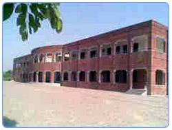
Education
Higher / Technical Education
 At
the government level, University Of Engineering, Taxila established a
temporary campus in the At
the government level, University Of Engineering, Taxila established a
temporary campus in the
city and work is underway for the construction of a Campus building.
A new Government College for Women is also being established in Balkassar.
In the private sector, a polytechnic college called the Swedish Institute of
Technology has been
established by a nationwide educational chain.
Two commerce colleges affiliated with University of The Punjab have also
been started in the private sector called CSC College of Commerce and Myer's
College of Commerce.
A campus affiliated with a virtual university called the Global Institute
has also been established in Chakwal
Allama Iqbal Open University,Islamabad (AIOU) has started its regional
campus in Chakwal City in 2007.This campus is situated in the Mohalla Basti
Allah Wali, Near Girls College, Chakwal.Since then it has been functioning
very efficiently and catering the thousands of distance education student of
the district.The students are now facilitated here in this centre and they
don't have any need to go to Islamabad.
Dr. Aftab Ahmed Mughal who is a renowned educationist of the district, is
presently working as the Regional Director of AIOU Chkawl Region.
Schools
The Arya Samaj founded the first ever school in Chakwal at the start of the
20th Century. It was followed by a Khalsa School. Islamia school was the
first school established by a society of Muslims. The Government School for
boys was established in 1930's. In the 1960s Yousaf Saigol, a business
tycoon and owner of the famous Saigol Group built the first modern school in
his native village Saigolabad.
Jinnah Public High School was founded in early 70s. Many old students of
Jinnah Public School are in Pakistan Armed Forces, telecom and IT companies.
Late Principle Mrs. Akram Sultana dedicated her whole life and effort to
make this school an example for all private institutes.
After Chakwal was declared a district by General (Shaheed) Zia Ul Haq) in
1986, a modern District Public School was established in the late 80's by
the government. (DPS) District Public Higher Secondary School is one one of
the best known schools of Chakwal District. It was founded in the 980s by
the district government. It is a semi government school for both boys and
girls. Since its foundation this school has produced good results. This
school was pioneered by renowned educationist Syed Muhammad Ali Wasti
(Late).
One of the leading colleges since 1989 is PAF Inter College Kallar Kahar. It
has produced several doctors, engineers, IT professionals.Lately, quite a
few good private schools have been established in the private sector. Fauji
Foundation, Khursheed International, The Educators,
Bahria Foundation, Noble House School and Nexus School Bhaun are providing
decent education in purpose built campuses.
A Cadet College,in private sector, was established in Kallar Kahar by
General Nazar Hussain in 1997. The College has produced excellent results
and is already in the league of top Cadet Colleges in Pakistan.
Myers College was founded in 1999 by Raja Yassir H. Sarfraz, a grandson of
Raja Muhammed Sarfraz Khan(late). The instituition is patterned after
English Public Schools and offers Cambridge O/A Level qualifications.In the
last few years, Myer's College students have shown some tremendous results
at the Cambridge International Examinations.
Go To Top
Newspapers and Magazines
Considering Chakwal's small population, the number of local newspapers being
published from here is relatively large. Dhan Kahoon is the oldest and most
popular local newspaper. Chakwal Point, Chakwal Nama, Press Forum, Aasar,
Dhudial Nama, Bab-e-Chakwal, Total and buttgam news are also published in
significant quantities. An English newspaper called, " The Revolution " is
also published in Chakwal. The first online newspaper was established by
Riaz Butt named as " Dhudialnews".
Monthly "Aabadiyat" is the first and so far the only Urdu magazine being
published from here and covers all spheres of life.
Go To Top
Libraries
Chakwal has only one public and very few private libraries, the largest of
these is the Allama Iqbal Library located at the committee park Most of the
volumes there are in Urdu. The Government College for boys has a library of
reasonable size and is open to the public. In the private sector, Myer's
Library located at Myers College, Kot Sarfraz Khan has a large number of
both English and Urdu books.
There are no public or private libraries for children in rural areas of
Chakwal.
Go To Top
Tourism
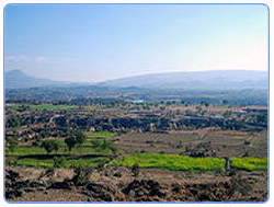 Chakwal
has landscape features including the canyons in Thirchak-Mahal and the
yellow beds of Chakwal
has landscape features including the canyons in Thirchak-Mahal and the
yellow beds of
muster"Surson". There are many man-made and natural lakes around the city in
Kallar Kahar, Dhok Talian, Kot Rajgan, Khai, Khokar Zer ,Dharabi and the
most beautiful village with all the
modern facilities is called KHAJULA.
The Jhangar valley, Bisharat is situated on the road coming from Choa Saidan
Shah facing West to
East about 8 km in length between the villages of Kotli and Ara at 3,000
feet (910 m) above sea
level. The weather during the summer is very pleasant and the hills are full
of green bushes and olive trees An interesting place of this valley is the
Picnic Point of Chehl Abdal” hill top which is at 3,500 feet (1,100 m) above
sea level. On the top of this hill is a shrine called Chehl-Abdal. Many
people from local villages and from all parts of the country often visit the
shrine and offer sacrifices. From the Chehl Abdal hill top one can see the
great Punjab plains. To the north are the Margla hills and to the south one
can see the Jhelum River. On the East & West side one can see the beautiful
greenery of adjoining hills with rain forests consisting of thick jungle
trees and bushes. Alexander the Great passed through this area (old Nandana
Fort) near Ara on his way to fight Raja Porus on the banks of the Jhelum
River in 326 BC.
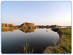 Another
well-known tourist place in the area is Kalar Kahar for which Zahir uddin
Baber said Kaller. Another
well-known tourist place in the area is Kalar Kahar for which Zahir uddin
Baber said Kaller.
Kahar is a child of Kashmir. Kalar Kahar is 2,500 feet (760 m) above sea
level
and Chehl Abdal is 3,500 feet (1,100 m) above sea level.
Larri pathan is another beautiful place in Chakwal. One faction of the Kakka
Zai Pathans migrated
from Afghanistan and settled in a village called Lari Pathan
The famous temple-fort of Katas Raj is nearby also Chakwal has a well
connected road network
including a road to Jhelum and Lahore via the Sohawa road, a road to Pind
Dadan Khan via the
Choa Siaden Shah road, a road to Sargodha via Bhon and Khushab, a road to
Rawalpindi via
Mandra and to Mianwali via the Talagang Road.
It is connected to the GT road between Peshawar and Lahore via Sohawa and
Mandra, the Indus
Highway via Mianwali, and M2 Motorway via Kallar Kahar and Balkassar exits.
The travelling
distances and time has reduced considerably to Lahore, Rawalpindi, Sargodha,
and Faislabad
since the commissioning of the M2 Motorway
Find more about
Pakistan Tourism Contacts
,
Worldwide Travel & Tourism
Go To Top
Agriculture
Chakwal is a semi-arid area with serious shortage of water for agriculture.
Over 70 per cent of the population engages in agriculture, mostly
subsistence agriculture that is dependent on rain. Most villages have no
irrigation system.
Go To Top
Food and Health
Satellite
View of Hospitals
The food which the people of Chakwal consume is very
modernized.biryani,halwa,chinease are most widely used.people are mostly
interested
in junk food from different and good resturants of chakwal like pehlwan
juice,corner sweets,makkah restaurant,pizza time etc.
The most well known and favourite food product coming from Chakwal is a
sweet called Riyori (pronounced ree-o-ree). It is about the size of an
M&M. it is basically a mixture of desi ghee (clarified butter) and gurr (jaggery)
covered with sesame seeds.no major health problems because
of hardworking and educated nature of people.
Go To Top |